

Where do you live? It’s a simple question to answer in most cases, but when it comes to buying property, real estate, title, and mortgage professionals don’t rely on the address. An address simply doesn’t give enough unique property information.
Perhaps it’s the property identification number (PIN) or parcel number that you’ve spotted on your tax bill? No, even this number doesn’t pass muster for the vital work behind the scenes of a real estate closing.
Instead, the legal description acts as the primary property identifier in every real estate transaction.
What does a legal description do?
A legal description provides assurances that other forms of property identification can’t. The legal description performs three critical functions:
- Identifies a property’s location
- Lists measurements of the property
- Describes all necessary location information to identify a plot of land
As a result, the legal description has a huge impact on land value as the accuracy in measuring land bolsters people’s confidence in buying, selling, insuring, and investing in it.
Examples of legal descriptions
There are three different methods of creating a legal description, which includes:
- Rectangular Government Survey (or Fractional)
- Metes and Bounds
- Lot and Block Number on a Plat Map
Each provides the instructions a land surveyor will follow to measure the property and ensure it is accurate.
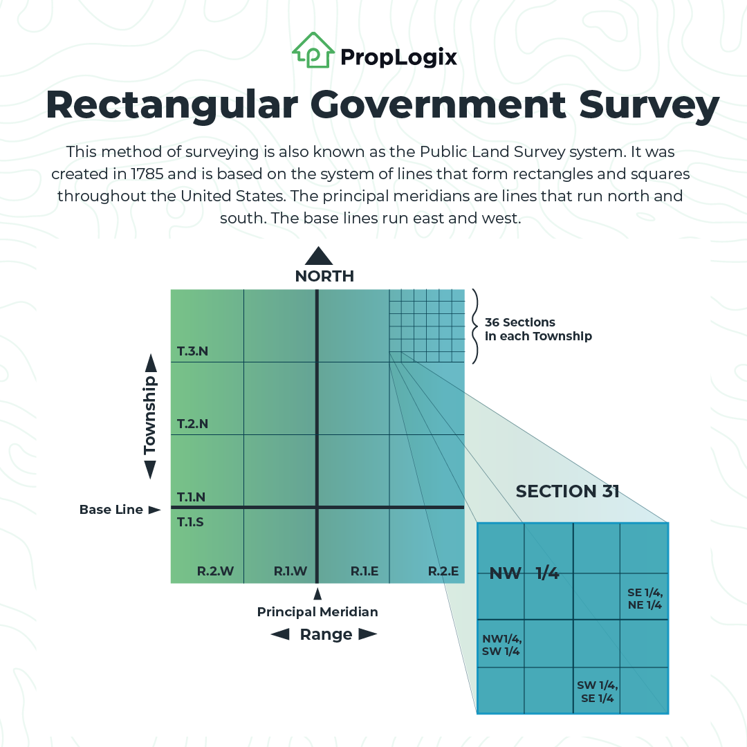
Rectangular Government Survey
This system, sometimes called the Public Land Survey System, was created in 1785 to plat or divide real property into squares and rectangles for sale and settling. It is primarily used throughout the United States with the exception of the thirteen colonies, which was surveyed by the metes and bound method inherited from the British. Although the system was a costly investment, it established more reliable legal descriptions. A legal description using this system will reference the sections to find the property:
SW ½ NW ¼, S9, T4N, R5W
or
The southwest half of the Northwest quarter of a section nine, township four North, range five West.
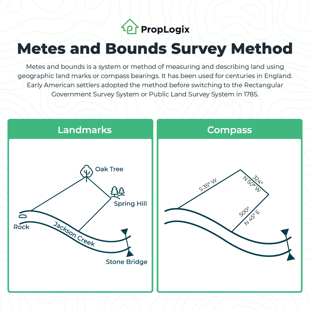
Metes and Bounds
The metes and bounds method is the oldest and most common way to measure land by which the surveyor finds a starting point, called the point of beginning, and proceeds with directions, angles, and distances. Traditionally, it utilizes visual and geographic markers, landmarks or monuments, to create the legal description, but it may also be used in conjunction with the Rectangular Government Survey System or a compass, depending on where the land is located. A typical example of a metes and bounds found in the original colonies may read something like:
“From the point on the north bank of Jones Creek one mile west of the Stone Bridge, northeast 400 yards to Spring Hill, then northwest to the large oak tree, then southwest to the rock at the north side of Jackson Creek, then along the north bank of the creek to the starting point.”
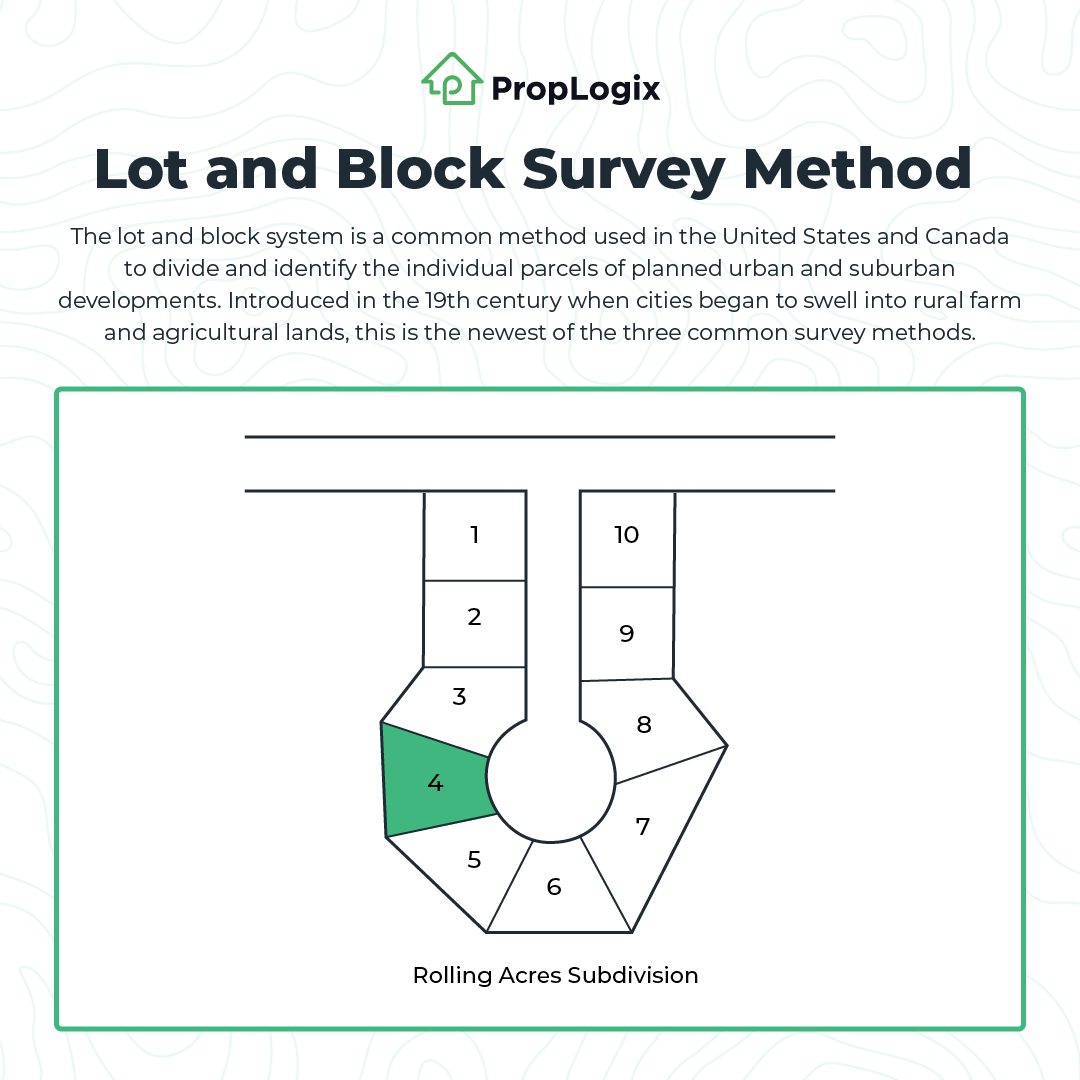
Lot and Block
This legal description is part of a planned subdivision on a plat map. Tracts of land are surveyed according to local surveying standards and ordinances to identify the perimeter of the land to be divided into neighborhoods, first by block and then by lot. The plat must be recorded to make the legal descriptions of the houses within it valid. Once the plat is mapped out and recorded, the smaller parcels are identified by letters or numbers, so the legal description of a house within a typical subdivision will look something like:
Lot 4, Block B, Rolling Acres Subdivision, Pinellas County, Florida.
Where do you find the legal description?
The legal description can be found in several important documents related to real estate.
- Land surveys
- Deed, deed attachment, or exhibit
- Title Commitment
- Real estate contract
Most of these documents aren’t easily accessible. Your best bet to finding the legal description is to locate the deed to the property in the public record. You can visit your county clerk of the court’s website or office to find the deed. Most counties have this information online, and you can search by address, owner name, or parcel number.
What are some common problems with legal descriptions?
The metes and bounds method allows for highly customized language to communicate the measurement of land. Still, critics point out these descriptions cause confusion, lack standardization, and harm the future marketability of the property’s title.
Wrong Legal Description
If you see any issues with the legal description, the deed must be corrected. This will create a cloud or defect on the title until it’s resolved. Usually, title agents will find these issues and work to resolve them before a real estate transaction. If a current homeowner requires a correction on the legal description, a local real estate attorney or title company may be able to help.
Partial legal descriptions
Some documents may not list the full legal description. As you may have noticed, some descriptions can be lengthy, especially metes and bounds descriptions, so it’s common to shorten them in some documents. To complete a survey or issue a title policy, the complete legal description must be referenced.
Unexpected Tax Assessments
Property is assessed for taxes by its legal description as well as parcel number. In some cases, homeowners have been caught off guard by PIN slamming because they were unaware that the legal description included more than one lot. This can cause unexpected financial burdens for new homeowners.
When should I get a new land survey?
A new land survey isn’t always required by a lender to finance a sale, but it’s still a good idea to ask for a new one to confirm there are no issues with the legal description or other boundary problems. Without a land survey, a homeowner or investor usually can’t request that the title company insure against boundary disputes in the title commitment.
Learn more about legal descriptions and the role land surveys play in protecting new property owners in this webinar!