

Every settlement agent worth their salt understands how important the legal description is in a real estate transaction. It’s especially important in a commercial real estate deal, where an investor needs to know exactly what they’re getting, but an incorrect legal description can also have dire consequences for a homebuyer. The legal description is an equally important tool for surveyors.
Homebuyers and even homeowners may not be as familiar with this term, so here are some important things to know about this part of real estate due diligence.
What’s a legal description?
A legal description of real property is a way to accurately pinpoint where a particular piece of property is located. This is typically based on existing township grids and uses a combination of alphabetical abbreviations and numbers to locate the land.
Sign up for our upcoming webinar on land surveys to learn more!
Why does the legal description matter?
“Surveyors should never use an address to survey because an address could be wrong. Using the legal description tells us exactly where the property is at by locating those certain permanent reference points, or monument points, to find the property. If a surveyor is working based on the address, they could be surveying the wrong property.”
– Akkad Bakhsh , First Choice Surveying
Unlike a property address, the legal description is a totally unique identifier for properties. In order to be valid, it must close, meaning the lines describing the start and end must eventually meet. It must also be clearly defined. If there are two parcels of property with the same legal description, this is a potentially huge issue that will cloud the owners’ titles and possibly lead to litigation.
Settlement agents use the legal description to determine which property is to have the title conveyed from the seller to the buyer. Some of the problems agents might see include leaving part of the property behind or including too much property in the reconveyance because the deed and mortgage are recorded with an incorrect legal description. This could result in incredibly expensive title curative work in the future.
In order to avoid litigation, the best way to determine the accuracy and closure of a legal description and to confirm the boundaries of the property is to obtain a new land survey before closing. The description gives important instructions to the surveyor to follow in order to make this determination.
Different types of legal descriptions
As you examine the legal description of different properties, you may start to realize some differences and patterns emerge in how they are written. There are three main types you will most likely come across.
The three main types of legal descriptions include
- Lot and Block: Descriptions must identify the individual lot, the block in which that lot is located as well as a reference to find the cited plat map in the public record.
- Metes and Bounds: Uses bearings and distances to measure the circumference of the property described in the legal description.
- Fractional: Describes a property by breaking down a section. Certified corner records are used to calculate measurements and figure out lot and distances.
Townships and Ranges and Sections
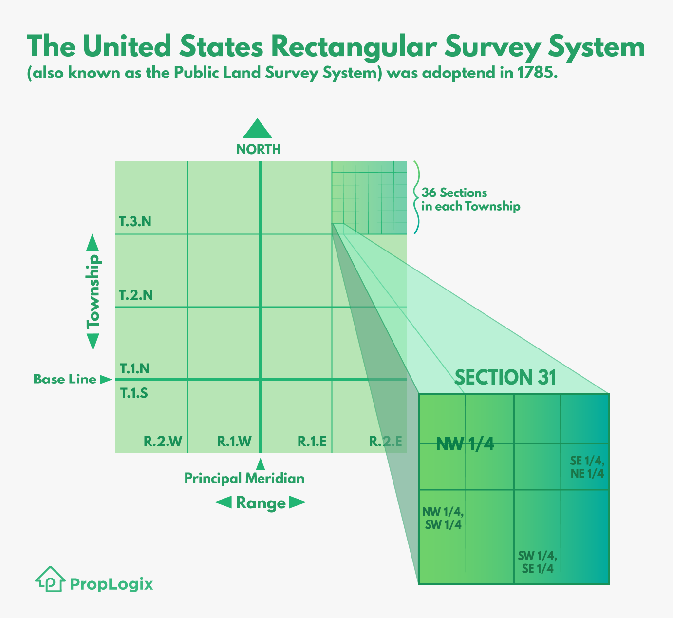
The government or rectangular survey system was adopted in the United States in 1785. Basically, this system breaks down counties and towns into a grid system. It’s based on the north-south lines of longitude, which are called meridians, and the east-west lines of latitude, which are called parallels.
Each part of the United States was assigned a specific parallel and meridian as a reference point. Township measures the distance north or south from the base line which is a designated parallel. Ranges measure east or west from the meridian.
Based upon these reference points, the land is divided into townships of 36 square miles. Townships are divided into 36 Sections of one square mile each. Each section is identified with a number based on its position. The northeasternmost section is 1. The northwesternmost section is 6 and below that section is number 7. The second row is numbered toward the east creating a snake like alternating pattern until Section 36 is reached at the southeasternmost corner.
Each section is divided further into quarters and so on.
Most homes within a developed community should lie within a township and range.
Lot and Block Surveys
This type of survey is the simplest to understand of the three most common survey types and are most often associated with planned subdivisions. Lot and block are the easiest surveys to do typically. Some caveats to the expected ease of these surveys will depend on the age of the property and if the corners and other landmarks mentioned are still present.
This type of description will contain:
- Individual lot
- Block located*
- Place of official recording
- Reference to cited plat map
*Some subdivisions may not be divided by blocks and may only list the lot number.
Example: Lot 225, Reflection Lakes at Naples-Phase 2C, a subdivision according to the plat thereof as recorded in Plat Book 46, Page 83, of the Public Records of Collier County, Florida.
Plat map
Every Lot & Block survey is part of plat map. Within the plat there is a permanent reference monument or control point that help determine an individual property’s location.
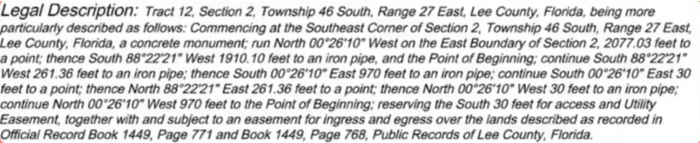
Metes and Bounds
This is a survey system that is based on physical features of its geography as well as directions and distances and will describe the property’s boundaries in terms of north and south.
This method is usually applied whenever land survey areas are irregularly sized and/or shaped, so that the boundaries of the property can be more clearly defined. Its ideal for undeveloped land in rural areas.
Metes is a piece of the property’s boundary line determined by measuring the distance between two points. It can also determine the plot of the plot of land’s direction.
Bounds is a term used to describe a property’s boundary line. Bounds are typically used to define properties with more acreage.
Monuments, also called survey markers or geodetic marks, are objects placed on the property to mark important survey points on the land’s surface. These objects are typically metal rods or concrete pieces lodged into the ground. Sometimes they can more unique objects like liquor bottles, clay pots, or rock cairns (piles).
In the United States, its a misdemeanor to intentionally destroy, remove, or deface permanent survey markers.
The legal description will describe a point of commencement and a point of beginning. The commencement point is meant to direct the surveyor to the point of beginning, which is where the property actually begins. Before surveyors can even begin to measure the property in question, they must find the correct Section, Township, Range, and monument of the point of commencement and then walk to the point of beginning with their equipment, making this type of survey more time consuming and laborious than a lot and block.
Example of a Metes and Bounds Legal Description:
Fractional
These descriptions are easiest to write but are the most difficult types of legal descriptions to survey. It describes a property by breaking down a section. This method takes additional time to calculate dimensions resulting in higher costs to conduct the survey.
Certified corner records are used to calculate measurements and figure out lot and distances. A corner record is a legal document filed with the county by a licensed land surveyor to document property corners.
To begin, the surveyor must locate three of the section’s certified corners. Each of these corners are a mile apart, so this means that the surveyor or surveyors must walk this distance with their equipment while following the instructions and measuring until they reach the specified point.
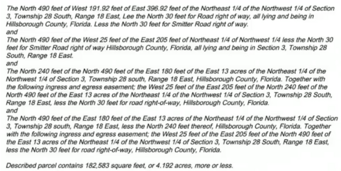
In this example, each paragraph is describing the location of a corner based on the certified corner records. Surveyors will start at the Section and begin cutting that section into smaller slices like a pie until they figure out where to locate each section corner.
How do homebuyers avoid issues with the legal description?
Title insurance was invented to protect property rights and help resolve issues resulting from confusing, forged, or unclear recorded documents. Lenders require this insurance to protect their interest in the property, so homebuyers will want to do the same. Having title insurance means that if you or your neighbor notice an issue with a legal description, you will be able to file a title claim to resolve the issue.
There is no easy fix to correct a legal description, and it requires an experienced title professional to resolve the issue.
Additionally, be sure to ask the title company that’s overseeing your real estate deal if a new survey will be conducted. Not all underwriters require a survey for all closings. As a result, an outdated survey may mean that an issue with the legal description goes undiscovered. Insisting on a new survey for every real estate transaction is the best way to ensure this kind of problem will be avoided. That way, the title agent and surveyor will catch any discrepancies in the legal description and move to clear the cloud on the title before the closing.